


Settings
-
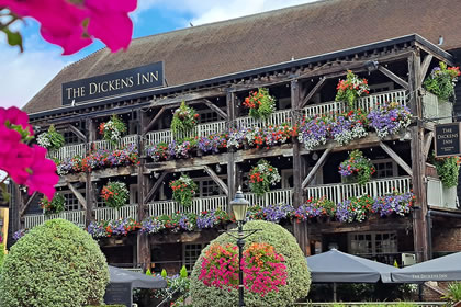
2 To the Dickens Inn
Turn right before the historic Ivory House and continue walking with the dock to your right past more restaurants, including the Melusine seafood restaurant.
Go through an arch in the buildings at the end of the row to the left of the Red Telephone box, and turn left. Another dock will be in front of you. Turn left, past some coffee shops, and head for the Dickens Inn across the ancient footbridges to your left.
Enter the Inn, which serves the following ales:
London Pride, Truman’s Fire Starter, Greene King IPA, Zephyr, London Glory Ale and Matt Smith IPA. If you are thirsty the Inn offers 2-pint “Steins”.
PLEASE NOTE it is a Cashless Pub.Take special note of the old footbridges near the Inn.
Take a few moments to read about the background to St Katharine’s Docks below and have a good look around the Inn. There are a number of small information boards dotted around the ground floor (to the right of the main bar, and on the wooden pillars opposite the bar which may help you answer the following questions. There are also some interesting old photographs of the area by the main entrance.
About the Docks
There have been docks in this important area, the Pool of London, and the City of London, close to the Tower of London, for hundreds of years. When the docks were first redeveloped in the 19th Century they were designed to create as much dockside space as possible. The two linked basins (East and West) are both accessed via an entrance lock from the Thames. Steam engines kept the water level in the basins about four feet above that of the tidal river. The docks were also specially designed so that the warehouses were built right on the quayside so that goods could be unloaded directly into them. This was to try to reduce stealing and pilfering between the ship and warehouse. The docks were opened on 25th October 1828.Although well used, the docks were not a great commercial success and were unable to accommodate large ships. The docks were badly damaged during WWII and all the warehouses around the eastern basin were destroyed, and the site remained derelict until the 1960s. The docks were formally closed in 1968, with redevelopment taking place in the early 1970s. Tower Hotel, which forms one corner of the front dock, was opened in 1973.
 Swipe left for next step
 -
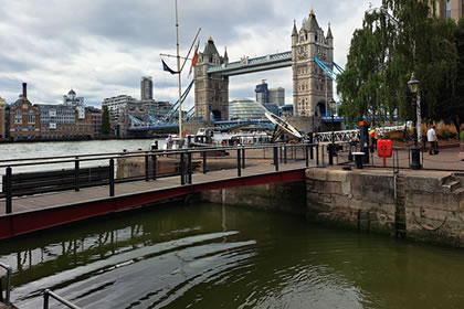
3 Towards the lock
On departing the Dickens Inn, turn left away from the footbridges. Walk towards the lock with the water on your right-hand side, past another red telephone box.
At the Lock, turn left and walk a very short distance towards the Thames, find the plaques that are on the brick wall on your left. Study the plaques and the name plaque on the wall and answer the following 3 questions:
Did you spot the spelling mistake on the plaque – Katharine’s is mis-spelt. Ooops!
 Swipe left for next step
 -
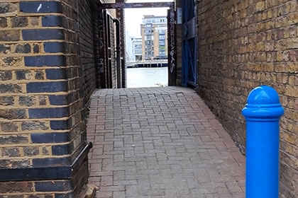
6 Alderman's Stairs
Continue walking about 20m, and on the right there is a well-hidden turning to Alderman’s Stairs.
Taking care, venture down the alleyway to Alderman’s Stairs to the river.
Enjoy a glimpse of the river – these stairs have been in constant use for many hundreds of years since mediaeval times. They were once a reference point for the ships mooring in the river. If the tide is out, you can access the foreshore but please take great care. If wet, the steps can be very slippery.
 There are no questions here.Swipe left for next step
 -
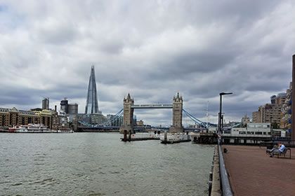
7 Tower Bridge Wharf
Return to St Katharine’s Way and take the next alley on the right at the sign for the Thames Path. Follow the Thames path down another alley which takes you to Tower Bridge Wharf and its viewing area with benches.
Enjoy the views and answer the following questions.
 Swipe left for next step
 -
8 Hermitage Riverside Memorial Gardens
Exit the viewing platform at the end farthest from Tower Bridge via an alley which leads you back to St Katharine’s Way. At St Katharine’s Way, continue to follow the Thames Path signs and turn right.
After about 20m the road merges into Wapping High Street. After another 20m turn sharp right and enter Hermitage Riverside Memorial Gardens. These gardens were built as a memorial to the East London civilians who lost their lives during the bombing of the area during World War II.
Take a few moments to enjoy the gardens and seek out the information plaque then answer the following questions:
 Swipe left for next step
 -
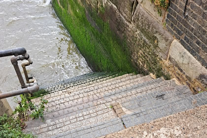
10 Town of Ramsgate pub
Continue along the road for another 20 meters and you will see the Town of Ramsgate pub.
Just before the pub entrance you will see a narrow alleyway. Venture down the alley, which leads to Wapping Old Stairs, a set of Watermen’s Steps. Take care on the stairs as they are very slippery – at high tide you will not be able to go down them.
Until 1750 the only place to cross the Thames was London Bridge, which was always busy and its gates were locked at curfew time. Therefore, most people used boats across the river and heading east and west. These river steps were the original “bus stops” for the ferries, and were often built close to pubs.
 Swipe left for next step
 -
11 Tavern stop No. 2
Return to Wapping High Street, and immediately turn right into the Town of Ramsgate tavern.
The Town of Ramsgate, 62 Wapping High Street, London E1W 2PN https://townoframsgate.pub
This pub serves: Young’s London Original,
Harvey’s Sussex, Wye Valley HPA real ales, and Whitstable Bay lagerPlease note it is a Cashless Bar.
Order a drink and then answer the following questions. There is a helpful historical information board near the front door which may help you with the questions.
Story of the pub. This is possibly the site of a pub dating back to the 15th Century. Known from 1533 as The Hostel, The Red Cow, then the Ramsgate Old Town and finally as the Town of Ramsgate. The pub is famed for its Christmas decorations.
 Swipe left for next step